

Coastal Morphology Group • Scripps Institution of Oceanography
The Present
|
To learn more about El Niño: • El Niño Theme Page, NOAA • El Niño / Southern Oscillation, NOAA |
How southern California beaches respond to historic climate trends
Dry periods are dominated by La Niña conditions, and the principal wave energy for the California coast is from
Aleutian lows.
El Niño episodes bring wet conditions, and high energy waves approach from the west.
During dry periods, winter storm fronts are from Aleutian lows and make landfall in Washington and Oregon so that California receives less rainfall and lower waves:
- prevailing southerly sand transport in winter
- low streamflow and decreased sediment flux to the coast
- narrow winter beaches and mild erosion of sea cliffs
- southern hemisphere swell of summer -- low energy waves from south move sand to the north during summer
During wet periods, winter storms are from the west and strike California directly with strong winds, high waves, and heavy rainfall:
- high energy waves and enormous sand transport up and down coast
- floods with high discharge of sediment at river mouths
- some beaches downdrift of stream deltas will accrete; away from river mouths, beaches disappear and sea cliffs erode
- summer wave climate less intense and some beaches return
How sand supply from streams responds to climate trends
Up to 90% of southern California's beach sand comes from streams. The streamflow and sediment flux data from the San Luis Rey River, the largest source of sand to the Oceanside littoral cell, dramatically demonstrate the effects of decades-long wet and dry climate periods.
For the 20 largest streams along the central and southern California coast, average annual sediment flux was about 5 times greater in the recent wet period. Due to the effects of strong El Niño events, the three major flood years generated 27 times the average annual sediment flux of the dry period!
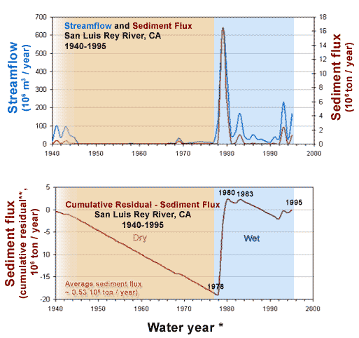
Streamflow and sediment flux for the San Luis Rey River, California, 1940-1995.
Click here to learn more about California floods and sediment flux.
Click here for data report.
* Definition of water year.
** Definition of cumulative residual
Coastal Morphology Group • Scripps Institution of Oceanography
©2002-2003 by the Regents of the University of California and the Kavli Institute.
All rights reserved.
Last modifed Monday, August 25, 2003