

Coastal Morphology Group • Scripps Institution of Oceanography
Beaches
 alifornia's 1,100 miles of coast include some of the world's most spectacular beaches.
Beaches are a recreational destination for 67% of Californians every year, a higher percentage than any other outdoor activity.
Beaches give us beauty and nourish our spirits.
Beaches provide diverse habitats for invertebrates, shorebirds, and marine mammals.
How do beaches form?
Beaches consist of the coarse erosion products of the land
(sand and pebbles)
and sea (shell and coral fragments).
Waves and currents sort the sediment and move it alongshore as a river of sand, predominantly to the south along the California coast. Coarser material remains closer to shore. Below mobile surface sediments, a bedrock platform slopes gently seaward and serves as a foundation for the beach.
Nearshore features related to the beach profile
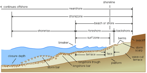
 Nearshore coastal features
Click here for the interactive diagram.
Nearshore coastal features
Click here for the interactive diagram.
Click on buttons to make a selection.
Equilibrium beach profiles
The equilibrium beach profile results from steady wave forcing during the seasonal cycle. Summer wave conditions move sand onto the beach. Winter storm waves move sand offshore. Unusually large storm events result in a disequilibrium profile, and sand may be permanently lost to deep water.
Summer and winter beach profiles are expressions of the seasonal cycle of wave energy. Due to storms, waves are larger and more energetic in winter than summer.
Long periods of stormy weather, such as El Niño winters, erode beaches to the underlying cobbles or bedrock and deposit sand far offshore in deep water, leaving the beach in disequilibrium.
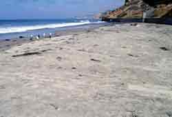 Zoom 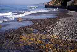 Zoom The summer beach is covered with a layer of sand that is moved south by the longshore currents and onshore by low waves. The winter beach is denuded of sand by high storm waves. Cobbles are heavier and remain on the beach. The wave-cut platform underlying the mobile sediments is visible in the foreground. Photographer - Pat Masters, images used with permission. |
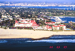 Zoom 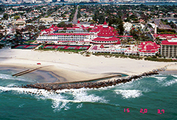 Zoom Photos courtesy Center for Coastal Geology, U.S. Geological Survey. The greatest erosion in the El Niño winter of 1997-98 occurred along the central California coast. Here on the south coast, even the groin has not retained the beach sand at the Hotel del Coronado following the El Niño storms of 1997-98. Farther south, the beach was eroded back to the seawall. More photos from U.S.G.S. |
Coastal Morphology Group • Scripps Institution of Oceanography
©2002-2003 by the Regents of the University of California and the Kavli Institute.
All rights reserved.
Last modifed Friday, June 25, 2003